Collection
Featured Collection
Search
Explore by Colour
Bird's Eye View
Explore by Agency/Maker
Explore by Object Type
Highlights
Advanced Search
My Shortlist
Collection
Featured
Highlights
Search
Explore by Colour
Bird's Eye View
Explore by Agency/Maker
Explore by Object Type
Advanced Search
My Shortlist
Back to main website
×
Searching for:
Search
Only get results with images
Object
Person
Refine Results
Refine results
Department
Community Archives Collection
252
Local Studies Photograph Collection
17
Local Studies Library
17
Object type
Photographic print - reproduction
17
Image Orientation
landscape
240
portrait
29
colour
More
Sort By
Relevance
Agency/Maker
Department
Object type
Subject category
Subject date
Production date
Title
Brief description
Accession date
Object number
Sort Descending
View
List
Label
Lightbox
More Options
View
List
Label
Lightbox
Shortlist
Add All to Shortlist
269 results. Displaying results 121 - 160.
«
2
3
4
5
6
»
Aerial of Parramatta City Centre from North to South, Burnie Banton Bridge and David Jones building in foreground
ACC002/102/025
Add to Shortlist
Aerial of Parramatta City Centre from East to West; Grose Street is in the foreground and railway line in the background
ACC002/102/026
Add to Shortlist
Aerial view of Parramatta River, Cumberland Oval, Old Kings Oval, Swimming pool, Stadium; Burnie Banton Bridge and Prince Alfred Park in foreground
ACC002/103/001
Add to Shortlist
Aerial view of Parramatta City centre from South to North, with Great Western Highway, Campbell Street and Church Street in the foreground and Parramatta Park and Westmead train Station in the background
ACC002/103/004
Add to Shortlist
Aerial view of intersection of The Boulevard and Hume Highway Strathfield
ACC002/104/005
Add to Shortlist
Aerial View of Blacktown shopping Centre WestPoint, tennis course and Train station are in the background
ACC002/105/004
Add to Shortlist
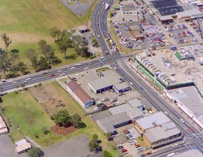
Aerial photo of a commercial area at Greenacre, Water tank at intersection of Hume Highway and Stacey Street
ACC002/059/001
Add to Shortlist
Aerial photo of a commercial area at Greenacre, Water tank at intersection of Hume Highway and Stacey Street
ACC002/059/002
Add to Shortlist
Aerial photo of a commercial area at Greenacre, near the intersection of Hume Highway and Stacey Street
ACC002/059/003
Add to Shortlist
Aerial photo of a commercial area at Greenacre, near the intersection of Hume Highway and Stacey Street
ACC002/059/004
Add to Shortlist
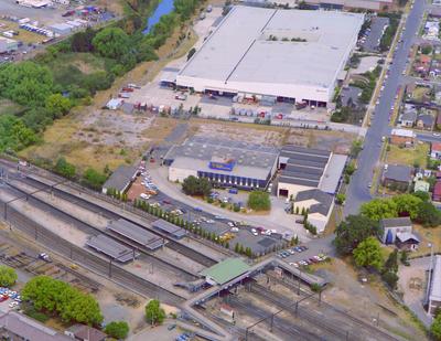
Aerial photo of commercial buildings near south side of Clyde Station, Factory Street
ACC002/059/010
Add to Shortlist
Aerial photo of commercial buildings near south side of Clyde Station, Factory Street
ACC002/059/011
Add to Shortlist
Aerial photo of commercial buildings near south side of Clyde Station, Factory Street
ACC002/059/012
Add to Shortlist
Aerial photo of commercial buildings near south side of Clyde Station, Factory Street
ACC002/059/013
Add to Shortlist
Aerial photo of commercial buildings near south side of Clyde Station, Factory Street
ACC002/059/014
Add to Shortlist
Aerial photo of an industrial area, Banbury shop; unknown location
ACC002/059/016
Add to Shortlist
Aerial photo of an industrial area, Banbury shop; unknown location
ACC002/059/019
Add to Shortlist
Aerial photo of an industrial area, Goodyear, tyre and brake service shop; unknown location
ACC002/059/024
Add to Shortlist
Aerial view of Westmead Hospital with some buildings under construction, photo print
ACC002/061/003
Add to Shortlist
Aerial View of Parramatta train station and intersection of Church and Argyle Streets
ACC002/063/001
Add to Shortlist
Load More Records
Loading...
«
2
3
4
5
6
»